Cowes to Selsey Bill: Boat Fishing Marks
The following marks are all in the public domain, none of these are “secret”. They have been published in “Sea Angler” and “Fishing Marks for the Sea Angler” by Trevor Stewart. These are general areas each containing many local marks. The waypoints given are not exact fishing marks, go to these points then use your fishfinder to locate fish-holding features. Some will fish better on the ebb, others the flood. There are no short cuts to finding good marks, but this information will help get you in the general areas, then it is down to you to position the boat right over the fish-holding features.
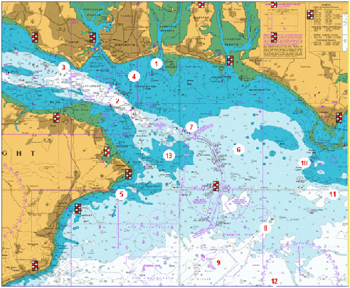
Click E_Solent_Marks to view and download a UKHO Chart showing these marks
- East and West Winner Banks, Langstone Harbour entrance. These banks extend south on either side of the entrance. The West Winner produces flatfish, small bream and shoal bass in summer. The East Winner is more dangerous as it dries at low tide, but a small and agile boat working close in to the breakers in suitable weather can connect with bass that chase bait fish into the surf.
- No Mans Land Fort and Horse Sand Fort stand either side of the main channel into the Eastern Solent. Both can be excellent mackerel and bass marks, if you drift with care around the forts. Small pollack can also be taken close to the walls of the forts.
- Stokes Bay. There are various marks along the drop-off as the shallow bay drops down to 80 feet and more into the channel. The tide runs very hard here and weed can be very troublesome – it is probably better as a winter mark when it is too rough outside. Try to anchor tight to the bottom of the slope, try 50 46.341N 001 08.944W or 50 46.604N 001 10.505W
- The Blocks are what remains of a submarine barrier, marked by posts. Bass can be caught along the blocks, and plaice show up in Spring on the East side of the blocks. Anywhere can work, from 100meters from shore all the way to the Fort, and from tight to the eastern side of the Blocks to 500 metres away. Plaice will feed over patches of mussel which are difficult to locate so try different places.
- Culver Spit. There are a number of marks along the rocky spit that extends from the white cliffs of Culver Cliff. Cod show in winter, with the usual summer species in the summer months. There is a deeper gully south of the bank that holds fish. Try this gully in the spit on the ebb 50 39.620N 001 05.009W
- Bullocks Patch. This holds bream from April onwards, and most species appear here at some time throughout the year. Some surprisingly large fish can be caught at times. 50 42.066N 000 54.919W is in the middle of the Patch.
- Deal Tail. This is the wreck of a coaster call Flag Theofano that sunk carrying a load of concrete. By the time salvage attempts started, the concrete had set hard and nothing could be done. Because the wreck is so close to the main shipping channel, it is marked by north and south cardinal buoys. It is an excellent summer mackerel mark, but mackerel shoal up in different areas from day to day so you may have to search around to find them. The wreck itself is teeming with small pollack and pouting. 50 43.080N 000 59.549W
- Utopia is a series of gullies that are very good summer tope marks. Fish the bottom of the steep sides of the gully, such as at 50 37.274N 000 53.715W or the “claw” at the north end.
- The Spoils is an area of rough ground and gullies. Look for any fish-holding bumps and gullies, and as this is a dumping ground be sure to trip your anchor as the bottom can be very snaggy.
- Boulder Bank. An excellent bream mark from April onwards. Try anywhere along the bank such as 50 41.298N 000 49.669W. The tide runs hard over the bank and floating weed can be a problem. Gullies to the north-west hold early tope and may be easier to fish if the tide is running hard.
- South East of Pullar – a number of banks in the area hold good bass. Some banks closer inshore and further east hold plaice, but the area also has shallow banks so take care when exploring.
- The Overfalls, an area of broken water where the tide runs hard. Some excellent ray and bass fishing. Go to 50 33.689N 000 53.868W and explore around until you find an obvious bank (there are many), then drift the bank with live sandeel for bass. The take area can be very precise, if you hit fish mark the spot and drift again. If you don’t find fish move on to another bank.
- New Grounds is an area of comparatively flat and featureless sea-bed, but good catches of bass, smoothound and ray can be had on the drift. This area is relatively sheltered from the prevailing south westerly winds. 50 41.950N 000 59.766W
Other areas worth exploring are the Hayling Shoal rocks (bass and smoothound in summer, trigger fish in the autumn), rocky banks in Sandown Bay (wrasse and bream); rocky outcrops west of the northern end of The Hounds for bream in April/May; the flat grounds a few hundred yards north of the Nab Tower (whiting in winter); areas immediately east of the Nab Channel buoys (whiting and cod in winter); the edges of Warner Shoal (drift for bass; small smoothound, bream and ray at anchor in the summer)
Wreck Sites
This information is from the Wreck Database . More details on each of the following wrecks are available on the Wrecks Site, which has historical information and dive details that describe the condition of the wreck and orientation.
Bettan 50.40.170N 001.00.570W
Camberwell 50.31.950N 001.02.800W
Cuba 50.36.000N 000.58.580W
Elford 50.38.080N 000.58.290W
France Aimee 50.40.050N 001.03.160W
Highland Brigade 50.34.500N 001.05.100W
HMS Velox 50.41.310N 001.02.050W
HMS Hazard 50.43.450N 001.03.140W
Mendi 50.27.280N 001.19.540W
P12 50.39.400N 001.05.000W
Prince Leopold 50.34.580N 000.55.870
Tweed 50.25.540N 001.19.360W
Wapello 50.31.530N 001.01.070W
War Knight 50.39.450N 001.31.020W
Westville 50.34.180N 001.26.360W